Table of Contents
The original proposed route for the highly controversial Peak Cluster pipeline has been altered, following large backlash and many consultation responses.
The scheme would capture 3 million tonnes of CO2 annually from the cement and lime industry in the Peak District and transport it via a 200km pipeline across the North West, to be stored in depleted gas fields in Morecambe Bay.
Peak Cluster has already requested access to land for surveys for the pipeline, which Wirral Council rejected in a unanimous meeting.
The opposition to the pipeline stems from concerns about the environmental damage it may cause, such as C02 leaks that could endanger wildlife and residents, and worry concerning the cost that the pipeline could incur, particularly for local councils.
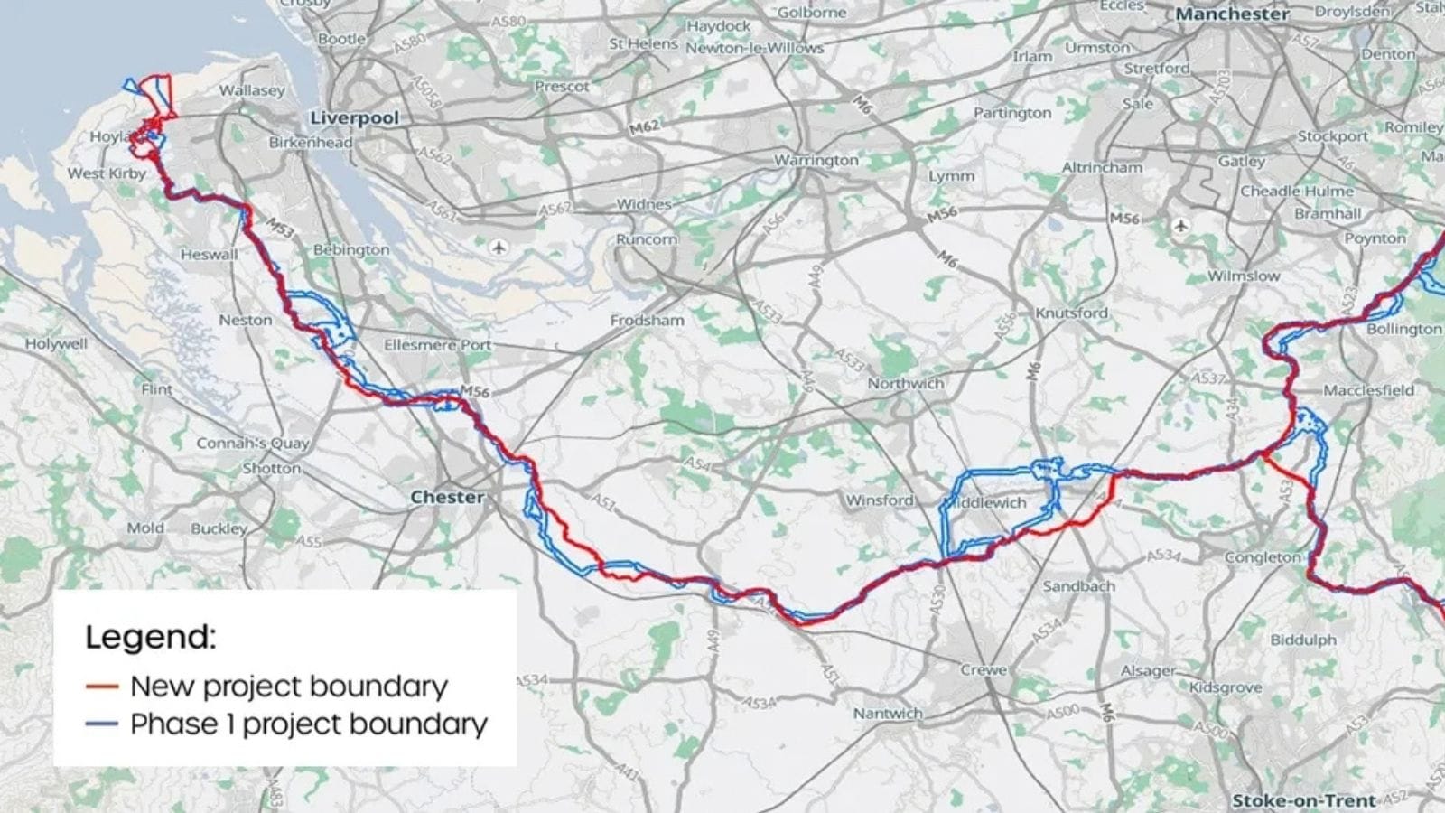
As reported by the Wirral Globe, around 15 per cent of the proposed pipeline route has been amended, with the corridor reduced from 300 metres to approximately 100 metres in most areas.
On 21 September, Peak Cluster issued an update on the boundaries.
While the modified route primarily affects land around Cheshire and High Peak, there are slight variations around the Neston area and some changes around Hoylake and Meols, where a large compression facility is marked for construction.
The proposed pipeline would cross the peninsula before reaching an above-ground installation between Meols and Moreton. Peak Cluster says the facility could include buildings up to 15 metres high and a vent stack up to 50 metres high.
Peak Cluster has identified boundary changes in five areas:
Southwest of Gawsworth and Moss Houses
Southeast of Holmes Chapel
Southeast of the Dove Holes Quarry to Tunstead AGI
South of Abbey Green, near Leek
North of Hargrave and Cotton Abbotts
The current boundary covers permanent infrastructure including the pipeline and above-ground installations. Peak Cluster said it has excluded land that may be needed for temporary access or construction, but precise locations for above-ground installations are still being worked out.
Residents can check the updated interactive map on the Peak Cluster website, although the final route and temporary construction areas have not yet been confirmed.
They have also said they have heavily used responses from the consultation to inform the changes. Peak Cluster received over 5,500 consultation responses!
David Parkin, chief executive of Peak Cluster Ltd, said in a statement: "The updated Project boundary demonstrates how we’ve engaged, heard and acted. It shows our commitment to continue working with local communities and stakeholders to develop a Project that takes into account groups’ priorities as far as possible, minimising local impact.
He continued, "We look forward to consulting with stakeholders and the public on these proposed changes, and the Project’s evolving design to further refine proposals.”
A consultation on Peak Cluster changes affecting the Wirral will begin in January.